
Every DOT faces the same challenge: developing a statewide intermodal program of transportation projects that are consistent with other state and regional plans and planning processes.
With that in mind, launching an interactive STIP site in a fraction of the time, while implementing the latest engagement best practices is a must have for public engagement success. But it can be difficult to implement if a standardized project website that captures every form of engagement isn’t in place.
Enter PublicInput’s interactive STIP sites, the easiest way to create project websites and to quickly collect input from residents.
Read on to see how Alaska DOT stood up an interactive STIP site on PublicInput in under two weeks and:
-
-
- Standardized their project page format using a STIP template project.
- Imported over 200 projects from their ESRI feature layer using the new Project Import Service.
- Launched an interactive STIP portal featuring their high-trust Alaska.gov brand identity.
-
Standardizing formats – the STIP project template
PublicInput’s drag and drop page builder made it easy for admins to quickly create visually appealing, accessible project websites. Each project page comes complete with a voicemail inbox, email, endpoint, and options for capturing every form of engagement, including social media, meetings, and more.
By working from a template, Alaska DOT&PF was able to create one standard for all STIP projects, which was then used to populate a project page for every project within the state transportation improvement program.
The template included merge fields for key project attributes like estimated cost, region, and congressional and senate districts. The template also included PublicInput fields for phone and email input options.
Creating an online home for every STIP project
Having a dedicated page for every public project is a best practice for a number of reasons:
-
-
- Ease-of-use for residents. Residents typically search for projects on search engines like Google, but search engines don’t index the data within common GIS applications where STIP projects are presented
- Less headaches for staff. Most DOT’s have one form or inbox for all STIP comments. When residents and stakeholders submit comments, they often refer to a project by colloquial names or road names. This can create a time-consuming headache, as staff have to discern what project – and who – this comment should be routed to.
With dedicated pages and comment forms, comments and contacts are instantly connected to the correct project record. - Continuity across project phases. The STIP represents an early step in a multi-step planning and project development process. By creating a digital home for the project early in the life cycle, all comments, stakeholders, and contacts are securely stored in a central system of record, and can be accessed by internal teams and consultants who are looped in as the project progresses.
-
Importing hundreds of projects from ESRI to PublicInput in minutes
Alaska’s planning team used PublicInput’s new ESRI Project Import Service, which can consume Feature Services hosted on ESRI’s ArcGIS online platform:
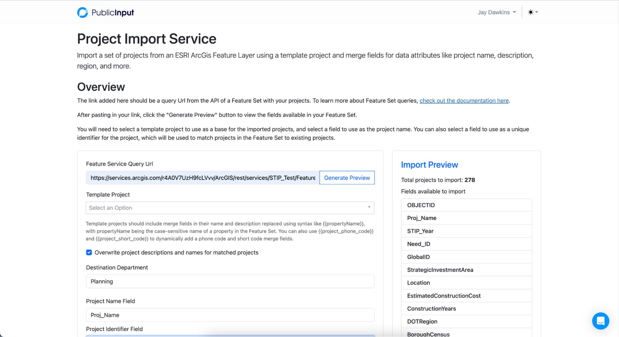
The new tool gives admins a preview of the properties and projects that will be imported, and supports merge fields in project page content to automatically populate dynamic project pages.
Here is an example project description template with merge fields:
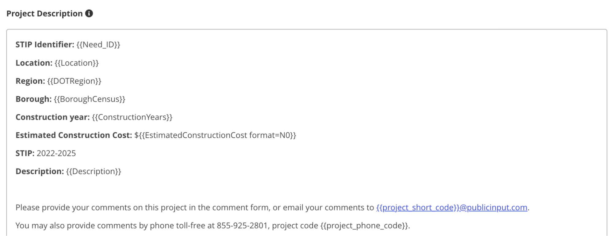
This template generates the content for the project websites, which also feature comment forms and quantitative questionnaires – all dynamically generated by the import service.
The best part: Even if your STIP is a work in progress, you can re-run the import and update existing live pages on the fly. Public comments and page links are preserved, updating only the project information that becomes available.
Interested in learning more about our interactive STIP project template? Book a demo today!
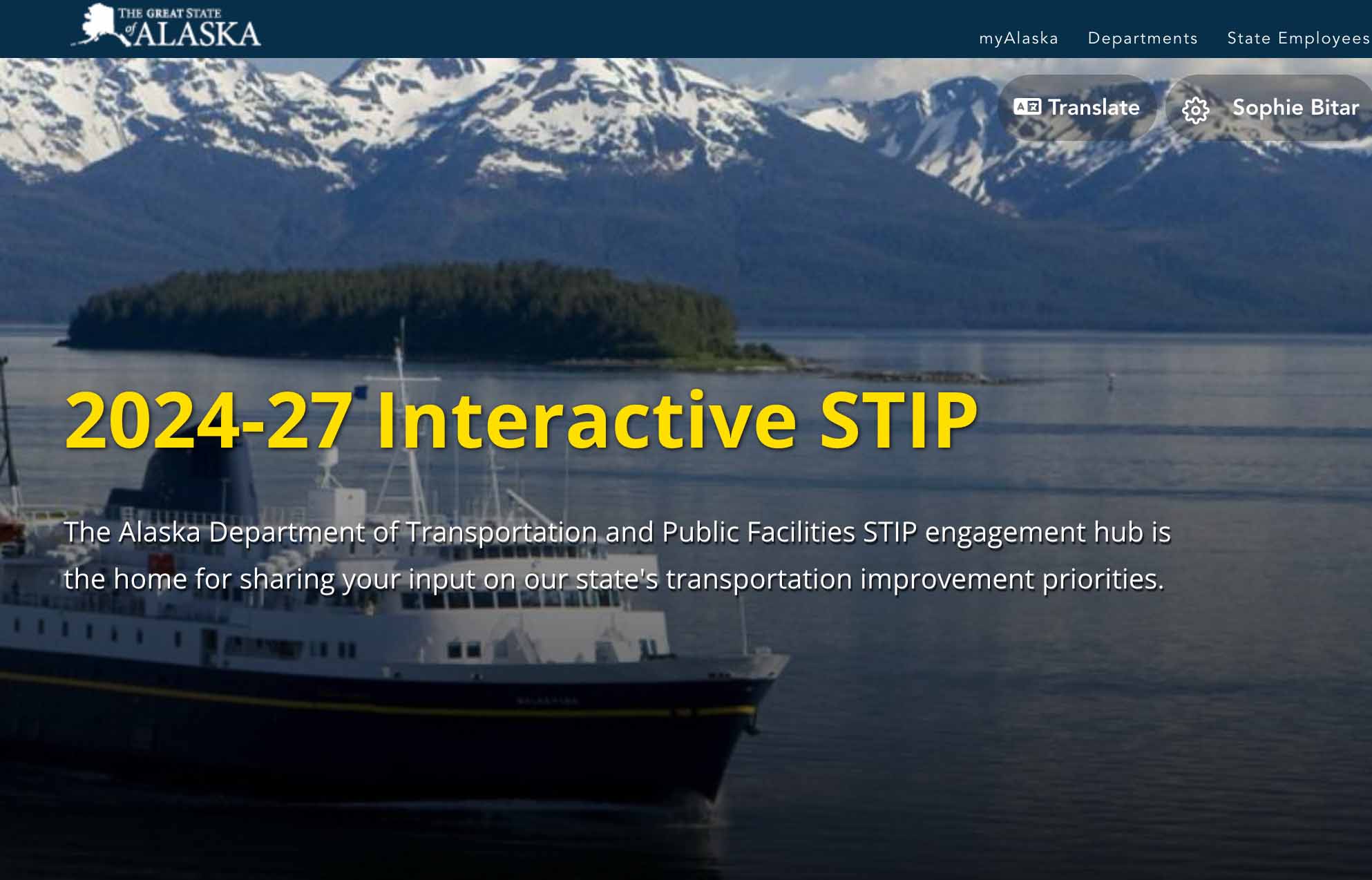
An interactive portal for gathering input on the STIP
One of the key benefits of a centralized engagement platform like PublicInput is the public portal. In one place, residents and stakeholders can explore the map, find projects, and provide input in one seamless experience.
In Alaska DOT&PF’s online portal, all located projects were assigned a latitude and longitude on an interactive map. PublicInput also supports line and shape locations, as well as a searchable interface for projects that do not have a location.

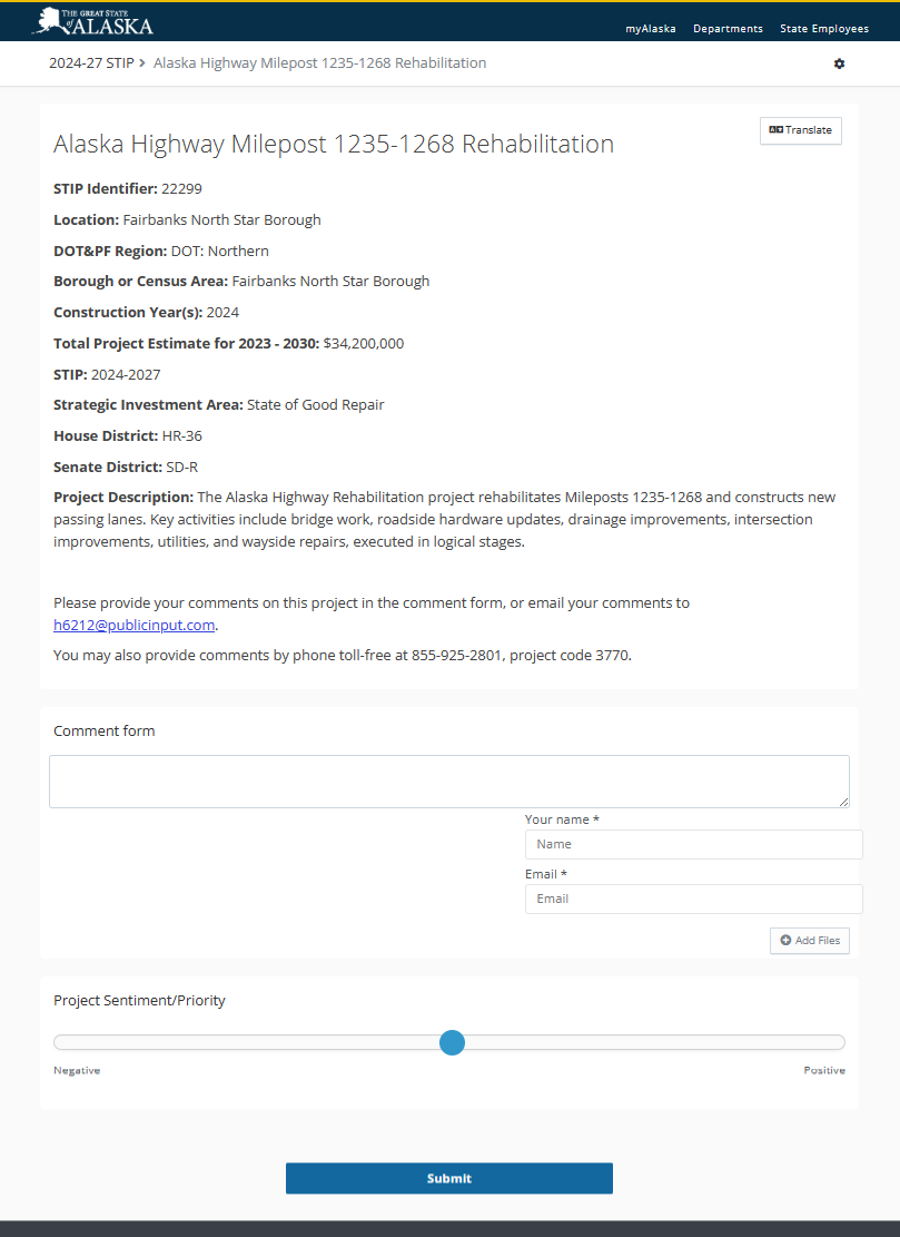
When residents click on a project, they see the project information along with an option to provide a comment on that specific project:
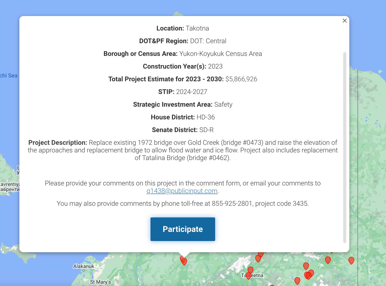
The result is a visually appealing, easy-to-use experience that has an added benefit of keeping all contacts and comments directly attached to projects.
Streamlining Comment Management with PublicInput
-
-
- Central Place for Managing Comments: With an influx of feedback and comments from various stakeholders, it can become challenging to manage and organize this valuable input. PublicInput provides a central hub where all comments are collated, ensuring that no feedback is overlooked. This centralized system offers a structured approach to comment management, allowing DOTs to process and respond effectively.
- Identify Key Stakeholders and Tag Them in Your Contact Database: Understanding who the key stakeholders are in transportation projects is pivotal. Because PublicInput includes an integrated contact database, you can quickly identify key stakeholders and see all of their engagement in one managed profile. You can even segment stakeholders by common attributes like group affiliations and geography to filter for key people you want to follow up with.
- Automate Replies to Participants: In today’s digital age, timely communication is essential. Automate and batch your replies, ensuring participants receive prompt responses without over-burdening staff. This not only streamlines staff workloads but also enhances the participant experience, building trust and fostering continued engagement.
- Report it All in One Place: Transparency and accountability are at the forefront of successful transportation projects. PublicInput’s comprehensive reporting tools allow you to consolidate all feedback, engagement metrics, and project updates in one place. With easy-to-access reports, DOTs can provide updates to stakeholders, ensuring transparency and building confidence in the planning and implementation processes.
-
PublicInput transforms the way DOTs engage with stakeholders, manage feedback, and report on transportation projects. It’s not just about collecting feedback; it’s about doing it efficiently, transparently, and inclusively.


